 Edwards Aquifer, source of our spring-fed rivers
|
|
HomeGuadalupe River Fly Fishing Guide TripsGift Cards and Gift CertificatesFly Fishing Classes, Lessons, and Instruction near Austin, San Antonio, and New Braunfels TexasDevils River Fishing Guide Fly Fishing TripsCanyon Lake Fishing GuidesSan Marcos River Fishing Guide TripsLatest Fishing Reports and River ConditionsFly Fishing Guide SchoolFly Fishing the Texas Coast for Redfish and Speckled TroutLlano River Fishing Guide TripsAbout UsTerms and ConditionsRio Grande River, TexasContact UsConservation Projects and InitiativesEdwards Aquifer, source of our spring-fed riversLinks for Information and LodgingGallery of PhotosPhoto Gallery IIPhoto Gallery III, "Fall Colors, Guadalupe River Valley"Fishing Guide Reports "Archives I"Fishing Guide Reports "Archives II"Fishing Guide Reports "Archives III"Fishing Guide Reports "Archives IV"Fishing Guide Reports "Archives V"Fishing Guides Reports "Archives VI"Fishing Guide Reports "Archives VII"Fishing Guide Reports "Archives VIII"Fishing Guide Reports "Archives IX"Fishing Guide Reports "Archives X"Fishing Guide Reports "Archives XI"Fish FactsGuadalupe River Flash Floods
|
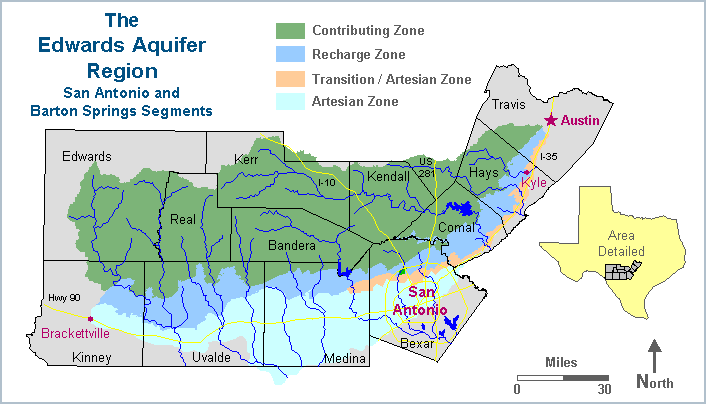
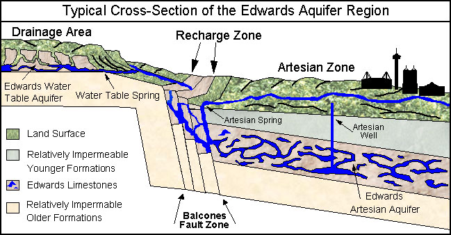
The Edwards Aquifer is an underground layer of porous, honeycombed, water-bearing rock that is between 300-700 feet thick. It includes the Edwards and some associated limestones. The San Antonio segment of the Aquifer extends in a 160 mile arch-shaped curve from Brackettville in the west to near Kyle in the northeast, and is between five and 40 miles wide at the surface. At these two locations, groundwater divides separate the San Antonio segment of the Aquifer from other Edwards limestones, so their waters do not mix. The Barton Springs segment extends from Kyle to south Austin (see map above). The San Antonio segment is where most of the major natural springs occur, where much of the use by humans takes place, and where the issues are most hotly-debated. A few major Edwards water features like Barton Springs and San Felipe Springs occur on the other side of the groundwater divides, to the north and west of the San Antonio portion. The image below shows a typical cross-sectional view of the Aquifer:
Contributing Zone The Aquifer is divided into three main zones: the contributing zone, the recharge zone, and the artesian zone. The contributing zone occurs on the Edwards Plateau, also called the Texas Hill Country. It is about 5,400 square miles, and elevations range between 1,000 and 2,300 feet above sea level. The rugged, rolling topography is covered with thick woodlands of oak and cedar. Today, the Edwards Plateau bears little resemblance to the prairies the pioneers to the area saw, but it is home to several endangered species and is itself the subject of increasing environmental concerns. The contributing zone is also called the drainage area or the catchment area. Here the land surface "catches" water from rainfall that averages about 30" per year, and water runs off into streams or infiltrates into the water table aquifer of the plateau. Runoff from the land surface and water table springs then both feed streams that flow over relatively impermeable limestones until they reach the recharge zone. The recharge zone is a 1,250 square mile area where highly faulted and fractured Edwards limestones outcrop at the land surface, allowing large quantities of water to flow into the Aquifer. For this reason, the Edwards is often called a fault-zone aquifer. About 75-80% of recharge occurs when streams and rivers cross the permeable formation and go underground. A small percentage occurs when precipitation falls directly on the outcrop. A surface water reservoir built partly on the recharge zone, Medina Lake, contributes large amounts of water to the Aquifer. Also, some recent models suggest that significant amounts of recharge enters the Edwards from the Trinity Aquifer, perhaps as much as 10% of the annual total. Most of the annual average recharge of about 711,600 acre feet (for the period 1934-2006) occurs in the western counties of Medina and Uvalde, where the Edwards outcrop is very wide at the surface. But rainfall is highly variable and so recharge amounts also vary widely from year to year. In the recharge zone there are no other rock formations overlying the Edwards - it is exposed at the surface. So the Aquifer here is "unconfined" and has a water table that rises and falls in response to rainfall. However, the major portion of the Edwards, the artesian zone, is confined between the Glen Rose limestone and the Del Rio clay, and it has no water table. Seco Creek Recharge Project
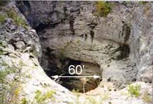
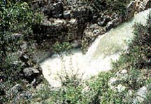
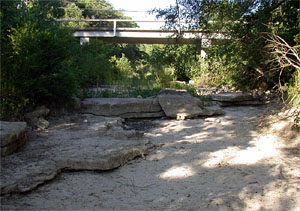
One way to figure out if a stream is on the recharge zone is to look for rocks that increase in elevation going downstream. In the photo at left, we are in the bed of Helotes Creek, looking downstream, in old downtown Helotes. Normally, streambeds decrease in elevation as they meander downstream and eventually confluence with another stream or reach sea level. But here, notice there are large blocks of limestone that are several feet higher than the creekbed in the foreground. This is an indication there was not enough water with sufficient velocity and erosive power to create a gradually graded streambed. The water disappeared underground instead of eroding the limestone.
Contributing Zone Within the Transition Zone
Once recharge water works its way by gravity down into the artesian zone, there are other rock formations lying over the Edwards, and water is trapped inside. The artesian zone of the Edwards is confined between two relatively impermeable formations - the Glen Rose formation below and the Del Rio clay on top. The sheer weight of new water entering the Aquifer in the recharge zone puts tremendous pressure on water that is already deeper down in the formation. Flowing artesian wells and springs exist where hydraulic pressure is sufficient to force water up through wells and faults to the surface. Major natural discharge occurs at San Marcos Springs and Comal Springs in the northeast. San Antonio Springs and San Pedro Springs in San Antonio are dry most of the time because large amounts of water are pumped from the ground by users in Bexar county, but they flow when Aquifer levels are very high. Water moves generally from southwest to northeast through the Aquifer and there are a number of barrier faults that make it difficult for waters in the various units of the Aquifer to mix together. These faults, along with varying porosities and permeabilities of the limestone, control the movement of water in the Aquifer fault. The J17 index well is used to monitor the amount of pressure that water in the artesian zone is under. Changing pressure is reflected in rising or falling well levels. |
||||||||||||||||||


