
Decisions are being made today that will have far-reaching and, in some cases, potentially irreparable impacts on the people of South Texas and northern Mexico, as well as on the area's sensitive ecology.
Without greater scientific understanding of the groundwater and surface water system, the potential impacts of these actions cannot be fully understood.
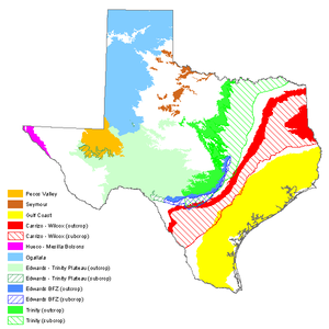
Map of major aquifers from the Texas Water Development Board.
The Edwards-Trinity Aquifer is a karst limestone aquifer that provides the majority of the water flowing in the Devils River. Due to the unique and complex hydraulics of karst aquifers, a clear understanding of the means and mechanisms by which water is conveyed from the headwaters of the watershed to the points of discharge is important for the effective management of these valuable resources.
The architecture of a karst aquifer is dominated by conduits and other features that allow water to pass through the limestone. Because these conduits are so numerous and complex, it is difficult to determine how different parts of the karst system relate to each other (and how pumping from one area will affect the others). More information is needed about the aquifer’s intricate structure – how water is moving through underground conduits, flowing from springs into streams, and seeping underground through caves and small openings in the limestone.
Recent scientific studies have begun to shed some light. For example, we now know that the Edwards-Trinity Aquifer provides about 76 percent of the source water for the Devils River (Green and Bertetti, 2010; Green et al., 2014). So pumping tens of billions of gallons of water, as has been recently proposed by water marketers, could have a significant negative impact on the Devils and numerous other waterways and springs, many of which provide drinking and irrigation water to towns throughout the region.
The accurate assessment of water availability in areas where resources are limited and stressed is of critical importance, but we do not yet have enough knowledge of the aquifer’s structure to fully understand the impact that over-pumping could have. DRC is currently working with hydrologists to study the intricacies of the Edwards-Trinity Aquifer and its relationship with surface water.
Below is the Executive Summary of the Southwest Research Institute's recent report,Investigating the Water Resources of the Western Edwards-Trinity Aquifer (or you can read the full report here).
A comprehensive assessment of the hydrogeology of the Edwards-Trinity Aquifer was undertaken to provide independent determination of “desired future conditions” for the western Edwards-Trinity Aquifer as required by HB 1976 (Mace et al., 2006). The Texas Water Development Board requests that a Texas Water Development Board approved groundwater management model (GAM) be used in the process of establishing Desired Future Conditions, but will accept alternative methodologies when uncertainty in GAM results is high. An acceptable alternative methodology is a quantitative water budget analysis. Water budget analyses were performed for an eight county area over the western Edwards-Trinity Aquifer. The eight counties included in the project were Crockett, Edwards, Kimble, Menard, Real, Schleicher, Sutton, and Val Verde. The assessments relied on water budget analyses of hydrologically distinct sub-areas in the western Edwards-Trinity Aquifer. Key findings during the study include the following:
- Groundwater catchments in the study area extend farther north compared with their overlying surface watersheds. Extension of a groundwater catchment from one surface watershed into another watershed results in groundwater piracy. Most notable are groundwater catchments for the Frio, Nueces, and Devils rivers.
- Counties with the greatest uncertainty in the water budget assessments are Crockett, Val Verde, and Menard. Crockett County has high uncertainty because it is part of a much larger hydrogeologic sub-area that includes the upper reaches of Pecos River and because there are limited data for the county. Val Verde County has high uncertainty because hydrologic conditions, including precipitation, vary significantly from east to west in the county. Menard County has high uncertainty because groundwater flow contributes significantly to the county water budget and this component has not been measured.
- River discharge measurements provide an opportunity to calculate recharge for the area that contributes to baseflow in the river. Long-term river discharge measurements were corrected for baseflow using an automated discharge recession separation algorithm. This analysis provided the fraction of total discharge that is attributed to baseflow.
- Long-term average annual river discharge values corrected to baseflow were converted to estimates for recharge for each contributing area analyzed. Refined groundwater catchment areas were assumed to be the contributing area for each discharge measurement.
- Recharge values were correlated with precipitation in the study area. The percentage of precipitation that recharged the Edwards-Trinity Aquifer varied from 7 percent in the eastern side of the study area where average annual precipitation is as high as 33 inch/year to 2 percent in the western side of the study area where average annual precipitation is 15 inch/year.
- Knowing the correlation between precipitation and recharge allowed prediction of how recharge in the study area will vary during periods when precipitation is less than the long-term average precipitation for extended periods.
- Recharge for each county in the study area was calculated for averageprecipitation conditions and predicted for periods when precipitation was reduced by 10, 20, and 30 percent. Calculated and predicted recharge is compared with recharge values assigned to the 2004 Edwards-Trinity Aquifer GAM and the groundwater availability documented in the 2007 Texas State Water Plan.
- Within the study area, Val Verde and Crockett counties are most vulnerable to drought because recharge is negligible when precipitation is reduced to less than 16-17 inch/year. Menard County is also vulnerable because it has minimal opportunity to store groundwater due to the limited thickness of the Edwards-Trinity Aquifer. Conversely, Real, Edwards, Kimble, and to a lesser degree, Sutton counties are less vulnerable to drought because they receive greater amounts of precipitation, on average, and their groundwater catchment areas extend beyond the extents of their surface watersheds.
Based on these findings, the sustainable yield of groundwater for each county is predicted using calculated recharge and recharge predicted for reduced precipitation. As examples, two plans are discussed. In Plan A, the sustainable yield of groundwater is set at 25 percent of calculated recharge for Crockett, Kimble, Menard, Schleicher, Sutton, and Val Verde counties and 15 percent for Edwards and Real counties. These percentages are reduced to 20 and 10 percent, respectively, in Plan B to reduce the risk to the water resource during periods of drought. Alternative calculations of sustainable yield of groundwater to reflect different risk levels can be made using recharge analysis results documented in this report.
\